All Cities
Japan·Asia·GMT+9 · valley light

Kyoto

Old capital. Every step is a bow.

Kyoto is a running meditation — the Kamo river, the temple lanes, the Path itself.

6 soul-aware routes · walking & running
Philosopher's Path — Stone canal path, gentle
First light·Stone canal path, gentle

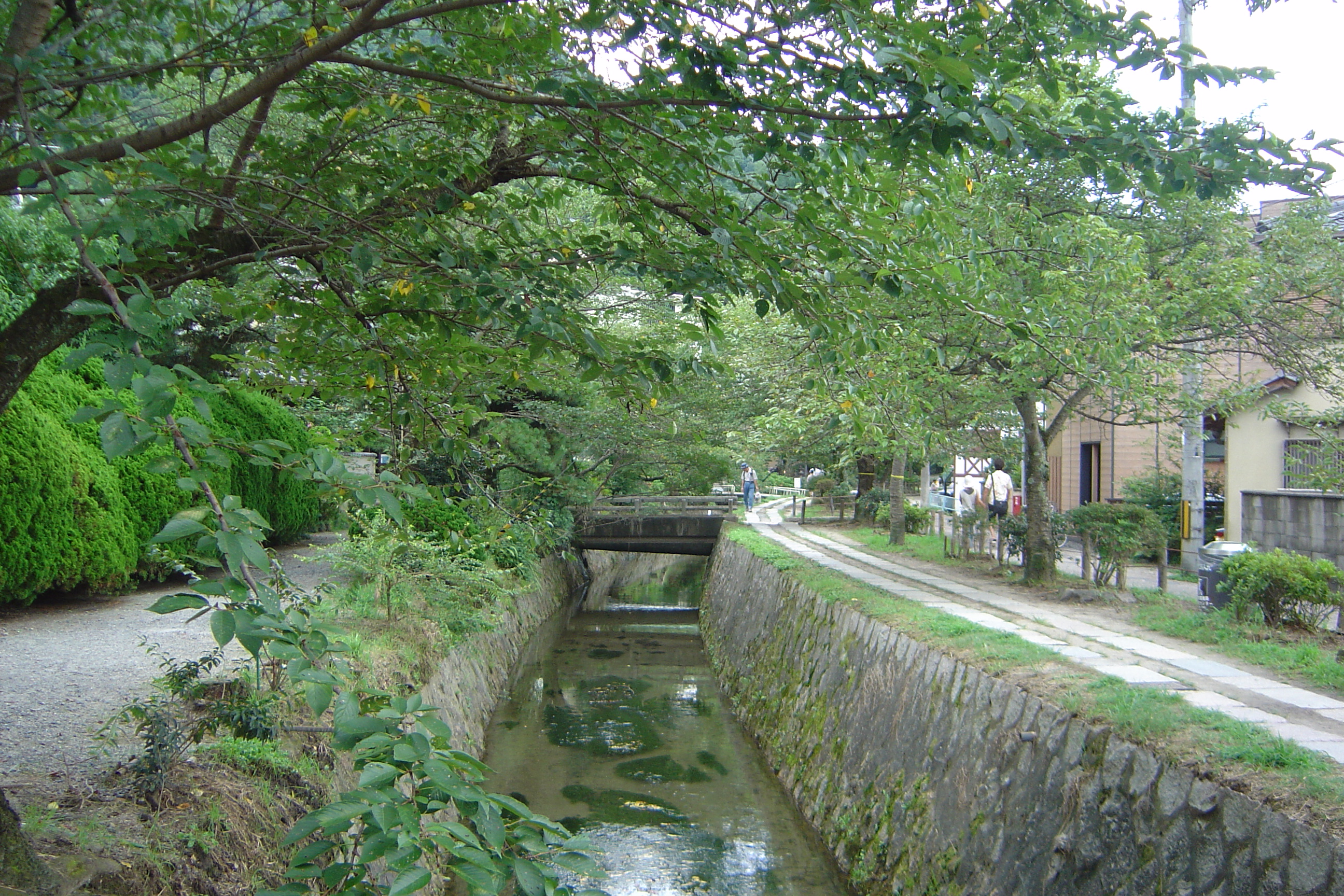
Philosopher's Path

5.6 km+40 m5:50 /km
Fully step-free
Wikimedia Commons · Philosopher's Walk

Stone canal, tea lanterns, footsteps as prayer.

Start
Ginkaku-ji approach · Philosopher's Path north (step-free · accessible bus 5)
End
Ginkaku-ji approach · Philosopher's Path north (loop returns to start)
Mindful-pace time
1 h walking · 32 min running
Step-free rating
★★★★★ Fully step-free · wheelchair & stroller friendly
Distance
5.6km
Elevation
+40m
Mindful tempo
5:50 /km
Elevation profilewide flagstone riverside path · gentle gradient · continuous
+11m0.01.42.84.25.6
+11 m gainPeak 11 m · 5.6 km
Elevation profile: total gain 11 metres, peak 11 m above start, low 0 m.
Tempo engine · Recovering
Nasal breath
5:43–6:17 /km

Nasal breath only. If you can't hold the nose, walk 20 steps and restart.

Accessibility · Fully step-free

Continuous wide flagstone riverside path · gentle gradient · continuous with curb cuts throughout. Wheelchair, mobility scooter and stroller friendly for the entire loop. Accessible toilets at each major entrance; every ramp under 5%.

Wheelchair Stroller Step-free
Along the way
  • WaterRefill fountains at each bridge and riverside plaza
  • BenchesTimber benches every 80 m facing the water
  • ToiletsAccessible toilets at the major bridges and river plazas
  • ShadeCherry, willow and plane canopy along most of the bank
  • Rest pointsBridge overlooks and river terraces — a river-facing sit anywhere
Why this route restores

Because the Philosopher's Path was worn by a century of thinkers walking beside a canal — every step here has already been made a prayer.

Snapped to real footpaths · Garmin · Strava · AllTrails · Komoot · Coros · Wahoo · Apple Watch · outdooractive
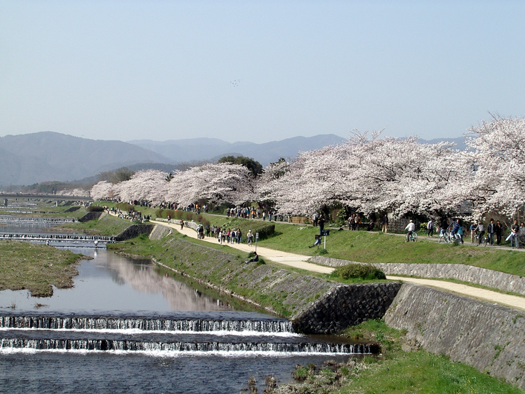
Kamo River Line — Riverside, flat, ceremonial
Dawn·Riverside, flat, ceremonial

Kamo River Line

10 km+20 m5:15 /km
Fully step-free
Wikimedia Commons · Kamo River

Herons, stepping stones, both banks quiet.

Start
Sanjo Bridge east bank (fully step-free · Sanjo Keihan station · continuous riverside)
End
Sanjo Bridge east bank (loop returns to start)
Mindful-pace time
1 h 30 min walking · 45 min running
Step-free rating
★★★★★ Fully step-free · wheelchair & stroller friendly
Distance
10km
Elevation
+20m
Mindful tempo
5:15 /km
Elevation profilewide flagstone riverside path · gentle gradient · continuous
+7m0.02.55.07.510.0
+7 m gainPeak 7 m · 10 km
Elevation profile: total gain 7 metres, peak 7 m above start, low 0 m.
Tempo engine · Flowing
5:07–5:39 /km

Ride the line. If effort spikes, ease back into the rhythm — don't push through.

Accessibility · Fully step-free

Continuous wide flagstone riverside path · gentle gradient · continuous with curb cuts throughout. Wheelchair, mobility scooter and stroller friendly for the entire loop. Accessible toilets at each major entrance; every ramp under 5%.

Wheelchair Stroller Step-free
Along the way
  • WaterRefill fountains at each bridge and riverside plaza
  • BenchesTimber benches every 80 m facing the water
  • ToiletsAccessible toilets at the major bridges and river plazas
  • ShadeCherry, willow and plane canopy along most of the bank
  • Rest pointsBridge overlooks and river terraces — a river-facing sit anywhere
Why this route restores

Because the Kamo is Kyoto's spine — herons at dawn, stepping stones at the confluence, both banks quiet enough to hear your own footfall.

Snapped to real footpaths · Garmin · Strava · AllTrails · Komoot · Coros · Wahoo · Apple Watch · outdooractive
Arashiyama Bamboo & Temples — Bamboo grove + temple path
First light·Bamboo grove + temple path

Arashiyama Bamboo & Temples

7.5 km+180 m5:45 /km
Mostly accessible
Wikimedia Commons · Arashiyama

Bamboo wind, temple gates, quiet climb.

Start
Arashiyama Togetsukyo Bridge (accessible from Saga-Arashiyama JR · bamboo grove flat)
End
Arashiyama Togetsukyo Bridge (loop returns to start)
Mindful-pace time
1 h 20 min walking · 40 min running
Step-free rating
★★★★☆ Mostly accessible · adaptive strollers and confident mobility users
Distance
7.5km
Elevation
+180m
Mindful tempo
5:45 /km
Elevation profilewide fine-gravel and stone temple approach · gentle undulation
+88m0.01.93.85.67.5
+88 m gainPeak 88 m · 7.5 km
Elevation profile: total gain 88 metres, peak 88 m above start, low 0 m.
Tempo engine · Recovering
Nasal breath
5:38–6:26 /km

Nasal breath only. If you can't hold the nose, walk 20 steps and restart.

Accessibility · Mostly accessible

Predominantly wide fine-gravel and stone temple approach · gentle undulation with a few brief unpaved sections. Off-road strollers and adaptive trail chairs manage well; standard road wheelchairs can complete the paved core.

Wheelchair Stroller Step-free
Along the way
  • WaterPurification pavilions (temizuya) and refill fountains at the shrine plazas
  • BenchesTimber log benches every 150–200 m along the sacred path
  • ToiletsAccessible toilets at the main shrine plaza and gate approaches
  • ShadeDeep old-growth canopy for the entire approach
  • Rest pointsShrine forecourt semicircle, inner garden overlook — each a reverent pause
Why this route restores

Because the Arashiyama bamboo grove is a sound before it is a sight — walk it at first light and the wind through the canes will remember for you.

Snapped to real footpaths · Garmin · Strava · AllTrails · Komoot · Coros · Wahoo · Apple Watch · outdooractive
Imperial Palace Park Loop — Imperial park, gravel & pine
Morning·Imperial park, gravel & pine

Imperial Palace Park Loop

4 km+12 m5:40 /km
Fully step-free
Wikimedia Commons · Kyoto Imperial Palace

Wide gravel avenues, black pine, city held at arm's length.

Start
Kyoto Gyoen south gate (fully step-free · Marutamachi subway · Blue Badge parking)
End
Kyoto Gyoen south gate (loop returns to start)
Mindful-pace time
50 min walking · 25 min running
Step-free rating
★★★★★ Fully step-free · wheelchair & stroller friendly
Distance
4km
Elevation
+12m
Mindful tempo
5:40 /km
Elevation profilesmooth tarmac and fine-gravel park loop · continuous curb cuts
+5m0.01.02.03.04.0
+5 m gainPeak 5 m · 4 km
Elevation profile: total gain 5 metres, peak 5 m above start, low 0 m.
Tempo engine · Recovering
Nasal breath
5:32–6:03 /km

Nasal breath only. If you can't hold the nose, walk 20 steps and restart.

Accessibility · Fully step-free

Continuous smooth tarmac and fine-gravel park loop · continuous curb cuts with curb cuts throughout. Wheelchair, mobility scooter and stroller friendly for the entire loop. Accessible toilets at each major entrance; every ramp under 5%.

Wheelchair Stroller Step-free
Along the way
  • WaterRefill fountains at each park gate and the central pavilion
  • BenchesTimber benches every 80–120 m facing the lawns
  • ToiletsAccessible toilets at the main gate, pavilion and secondary entrances
  • ShadeAncient hardwood canopy on most of the loop
  • Rest pointsCentral pavilion, lawn edge, pond overlook — a proper sit anywhere
Why this route restores

Because the Imperial Park is a wide open sanctuary of gravel and pine at the centre of Kyoto — the city agreeing, generation after generation, to hold space.

Snapped to real footpaths · Garmin · Strava · AllTrails · Komoot · Coros · Wahoo · Apple Watch · outdooractive
Fushimi Inari Torii Ascent — Vermilion torii mountain path
First light·Vermilion torii mountain path

Fushimi Inari Torii Ascent

4 km+230 m6:10 /km
Mostly accessible
Wikimedia Commons · Fushimi Inari-taisha

Ten thousand torii climbing — the slow flame.

Start
Fushimi Inari Taisha main gate (accessible from Inari JR · torii ascent begins immediately)
End
Fushimi Inari Taisha main gate (loop returns to start)
Mindful-pace time
1 h 30 min walking · 50 min running
Step-free rating
★★★★☆ Mostly accessible · adaptive strollers and confident mobility users
Distance
4km
Elevation
+230m
Mindful tempo
6:10 /km
Elevation profilewide fine-gravel and stone temple approach · gentle undulation
+117m0.01.02.03.04.0
+117 m gainPeak 117 m · 4 km
Elevation profile: total gain 117 metres, peak 117 m above start, low 0 m.
Tempo engine · Ascending
6:02–6:55 /km

Trade cadence for breath on the climbs. Descend soft-footed, not fast.

Accessibility · Mostly accessible

Predominantly wide fine-gravel and stone temple approach · gentle undulation with a few brief unpaved sections. Off-road strollers and adaptive trail chairs manage well; standard road wheelchairs can complete the paved core.

Wheelchair Stroller Step-free
Along the way
  • WaterPurification pavilions (temizuya) and refill fountains at the shrine plazas
  • BenchesTimber log benches every 150–200 m along the sacred path
  • ToiletsAccessible toilets at the main shrine plaza and gate approaches
  • ShadeDeep old-growth canopy for the entire approach
  • Rest pointsShrine forecourt semicircle, inner garden overlook — each a reverent pause
Why this route restores

Because Fushimi Inari's ten thousand torii climb the mountain like a slow flame — go early, breathe long, let the vermilion carry you.

Snapped to real footpaths · Garmin · Strava · AllTrails · Komoot · Coros · Wahoo · Apple Watch · outdooractive
Kamigamo Shrine Forest — Shrine forest & creek
First light·Shrine forest & creek

Kamigamo Shrine Forest

5 km+25 m5:45 /km
Mostly accessible
Wikimedia Commons · Kamigamo Shrine

1300 years of ceremonial ground; a creek keeping the time.

Start
Kamigamo-jinja main torii (accessible bus 4 · shrine forest fully flat)
End
Kamigamo-jinja main torii (loop returns to start)
Mindful-pace time
1 h walking · 30 min running
Step-free rating
★★★★☆ Mostly accessible · adaptive strollers and confident mobility users
Distance
5km
Elevation
+25m
Mindful tempo
5:45 /km
Elevation profilewide fine-gravel and stone temple approach · gentle undulation
+13m0.01.32.53.85.0
+13 m gainPeak 13 m · 5 km
Elevation profile: total gain 13 metres, peak 13 m above start, low 0 m.
Tempo engine · Recovering
Nasal breath
5:38–6:11 /km

Nasal breath only. If you can't hold the nose, walk 20 steps and restart.

Accessibility · Mostly accessible

Predominantly wide fine-gravel and stone temple approach · gentle undulation with a few brief unpaved sections. Off-road strollers and adaptive trail chairs manage well; standard road wheelchairs can complete the paved core.

Wheelchair Stroller Step-free
Along the way
  • WaterPurification pavilions (temizuya) and refill fountains at the shrine plazas
  • BenchesTimber log benches every 150–200 m along the sacred path
  • ToiletsAccessible toilets at the main shrine plaza and gate approaches
  • ShadeDeep old-growth canopy for the entire approach
  • Rest pointsShrine forecourt semicircle, inner garden overlook — each a reverent pause
Why this route restores

Because Kamigamo is one of Kyoto's oldest shrines — a forest, a creek, a wide ceremonial approach that has been walked for 1300 years.

Snapped to real footpaths · Garmin · Strava · AllTrails · Komoot · Coros · Wahoo · Apple Watch · outdooractive
Xymove Composer

Compose a soul-tuned loop

Give it a starting point and a feeling. Xymove reads the land, the light and the soul character — and answers with one composed loop, not a list.

Time of day
Soul emphasis · (2/4)
2 of 4 chosen

One composed loop — real footpaths, park lanes and quiet corridors only. Never a list.

All Cities
One shared standard · Four tempos

The PureSoul family moves with the same heart. Choose the tempo the day is asking for.

Visit the PureSoul Family hub

Shared maps · shared GPX engine · shared Soul Signature language. Whichever door you enter, the craft standard is the same.